


Mountain Biking - Bay Area - North Bay
- Annadel State Park(max singletrack loop)

- Boggs Mountain (max singletrack loop)
- Camp Tamarancho
- China Camp (max singletrack loop)
- Eldridge Grade/East Peak Mt. Tam Loop (from Phoenix Lake)
- Lakes Loop from Phoenix Lake (Mt. Tam Watershed)
- Marin Headlands Mega-Loop (from Tennessee Valley)
- Pine Mountain Loop (Mt. Tam Watershed)
- From Channel Drive, head up the singletrack Cobblestone Trail (across from dirt parking area)
- L on Orchard Trail
- R onto Rough Go Trail
- Pass over dam at Lake Ilsanjo
- R onto Canyon Trail fire road
- L up the Marsh Trail (wide singletrack)
- R onto Upper Steve's Trail/Ridge Trail
- Follow 3 mi to Ledson Marsh
- R onto Pig Flat Trail (haven't done this part of the loop - I took a L on Marsh Trail; saw no sign for Pig Flat Trail but think if you take a R on Marsh Trail you will reach Pig Flat Trail - please let me know and I'll update this!)
- Cross powerlines, becomes Schultz Trail
- Singletrack ends at Schultz Rd.
- Follow Schultz Rd. to the L to the junction with Lawndale Rd.
- L onto Lawndale Rd.
- L onto singletrack Lawndale Trail
- Follow back to Ledson Marsh and junction with marsh Trail
- R onto Marsh Trail
- Follow Marsh to Buick Meadow
- R onto South Burma Trail
- Continue straight (R) on fireroad at end of singletrack
- L off of fireroad onto North Burma Trail
- Follow all the way down to Channel Trail which parallels Channel Drive and ends at Park Office
- Follow Channel Drive back to parking
- US 101N to Santa Rosa
- Take CA-12 exit toward Sonoma
- L onto Farmer's Lane
- R onto Montgomery Drive
- R onto Channel Drive
- Follow Channel Drive to the left and park on left side dirt clearing (1/2 mile before Ranger station)
- Bike up the Cobblestone trail across the road
- Start at the Heliport, head up Fireroad 501 and take a right onto the singletrack Shaker Trail
- Climb the Shaker Trail and take a R on Fireroad 210
- Stay L at junction and immediately after the junction take a R onto singletrack Berry's Trail; this trail becomes the Crew Trail
- At end of Crew Trail, take a L onto fireroad
- Follow fireroad and take a R onto singletrack John's Trail
- At end of John's Trail, take a L onto fireroad
- Follow fireroad and take a R onto singletrack Big Springs Trail
- Take a L onto Fireroad 100
- Pass a fireroad on the L and then veer L onto the Grizzly Trail
- Follow Grizzly Trail for a considerable distance; at one point pass through a short stretch of fireroad and rejoin the Grizzly Trail
- At end of Grizzly Trail, veer L at junction with Fireroad 300
- Follow Fireroad 300 for short distance and take a L onto singletrack Jethro's Trail
- Climb up Jethro's Trail, cross over Fireroad 200 and continue on the singltrack Scout Trail
- Scout Trail will turn to fireroad, take a L onto singletrack Karen's Trail
- Just past lookout, take a L onto singletrack Karen's Trail
- At bottom of descent, stay to the R to continue on the Hobergs Loop Trail
- Follow this to bottom and stay to the R at next trail intersection (take a L to climb up and do the Hobergs Loop Trail again)
- Continue on Mac's Trail and finish with a switchbacking descent to the Heliport
- Climb in helicopter (if available) and fly back to SF
- US 101N past Santa Rosa to River Rd exit
- Right on Mark West Springs Rd, continue on Porter Creek Rd
- Left on Petrified Forest Rd
- Left on Foothill Blvd
- Right on Tubbs Ln
- Left on Calistoga Grade Rd, continue on CA-29
- In Middletown, take a left on Main St., continue on CA-175
- Go through Cobb and continue about 1.3 miles, take right onto Forestry Road
- Park near Heliport - see map
- US 101N to Central San Rafael Exit
- Merge onto Irwin St.
- L on 3rd St.
- R on Sir Francis Drake Blvd
- Park in town of Fairfax parking lots (local residents have complained about parking closer to the trailhead)
- On bike, continue on Sir Francis Drake Blvd for a 1/4 mile past the center of town
- L at sign to Camp Tamarancho
- R onto Monte Vista Rd., becomes Iron Springs Road
- Bike up Iron Springs Road to the trailhead on left side of road.
- From Campground entrance, jump onto the singletrack Bay Ridge Trail
- R at first junction, cross fireroad at 0.5 mi, and switchback to junction with Powerline Fire Trail at 1.0 mi
- Take an almost 180° turn to the L and proceed up along the Bay Ridge Trail
- Follow Bay Ridge Trail for 1.0 mi and stay L at junction with Echo Trail
- Follow fire road for short distance before taking a R back onto the singletrack Bay Ridge Trail
- Singletrack ends at junction with Ridge Fire Trail. Stay L on fire road and follow for 0.3 mi to Miwok Fire Trail
- Go down Miwok Fire Trail a very short distance and take a R onto the singletrack Oak Ridge Trail
- Follow the Oak Ridge Trail (stay on singletrack) for 1.2 miles
- Veer L onto Shoreline Trail and follow singletrack for 1.8 miles to junction with bottom of Miwok Fire Trail
- Cross over the Miwok Fire Trail and take flat road to the Miwok Meadows parking lot
- Pick up the singletrack Shoreline Trail on far side of parking lot and take a L at first trail junction to stay on the Shoreline Trail
- Follow Shoreline Trail around the Back Ranch Meadows Campground for 2.4 miles back to junction with Bay Area Ridge Trail
- Follow Bay Area Ridge Trail 0.1 mile back to start
- US 101N past San Rafael to N. San Pedro Rd. exit, veer right
- Follow signs to China Camp
- Park along San Pedro Road near the entrance to the Back Ranch Meadows campground
- Hwy 101N to Greenbrae/ Sir Francis Drake Blvd exit
- W on Sir Francis Drake Blvd for to Lagunitas Rd. in Ross, CA
- L on Lagunitas Rd., follow 1.5 miles to Natalie Coffin Greene Park
- Continue up the dirt road and park in parking lot
- From parking lot, cross bridge and climb to dam
- Head R (straight) at dam and meander around Phoenix Lake,
- R at 4-way junction onto Shaver Grade
- Climb 1.1 mi to Five Corners Junction
- Take a L and stay on Shaver Grade (climbs steeply)
- Take a L onto Sky Oaks Road (paved). Follow road to end parking lot.
- From parking lot, continue straight to Lake Lagunitas dam.
- Cross over dam and take a L. Follow trail around lake Lagunitas in CCW-direction
- Take a R at junction with Lakeview Trail
- Take a L onto Eldridge Grade
- Bomb down to original 4-way junction and take a R back to Phoenix Lake and the parking lot
- Hwy 101N to Greenbrae/ Sir Francis Drake Blvd exit
- W on Sir Francis Drake Blvd for to Lagunitas Rd. in Ross, CA
- L on Lagunitas Rd., follow 1.5 miles to Natalie Coffin Greene Park
- Continue up the dirt road and park in parking lot
- Start from the Tennessee Valley Rd. parking lot and take the left-most fire road (the Marincello Trail)
- Climb the Marincello Trail for 1.7 mi to junction with Bobcat Trail
- Follow Bobcat Trail for 2.7 mi, stay to the right at all trail junctions
- At bottom of downhill, take a right onto the Miwok Trail
- Climb the switchbacking Miwok trail for 1.4 miles to junction with Old Springs Trail
- Take a left onto the mostly singletrack Old Springs Trail and follow down for 2.0 mi back to parking lot. Boom done.
WANT MORE?
OK, add on the second part of the loop (from 5 to 8 miles, depending on route taken): - Start from the Tennessee Valley Rd. parking lot and take the the Tennessee Valley Trail toward the ocean for 1.3 mi.
- R onto Coastal Trail and a big climb for .7 mi
- R onto Coastal Fire Road, pass Fox Trail on R
AGAIN, YOU HAVE A CHOICE
The Mega-loop continues to the L on the Coastal Fire Road. Taking a R onto the Coyote Ridge Trail will cut out about 3 mi and an 800' ascent. To stay on the Mega-loop: - L on the Coastal Fire Road, downhill to Muir Beach
- R on Middle Green Gulth Trail (junction 500' before reaching beach parking lot)
- Go through Farm gate #1 and follow road .2
- At sign for Middle Green Gulch Trail before crop field, R and go through gate#2
- Singletrack climb begins (bikes allowed uphill only)
- L onto Coyote Ridge Trail, crest out just shy of height-of-land
- Start descending, R on Miwok Trail
- After entering forested section, R to stay on Miwok Trail (don't go L toward the house here)
- Follow Miwok downhill back to the parking lot
- Repeat as many times in a row as you wish/can
- US 101N to Stinson Beach/Hwy 1 exit
- L on Tennessee Valley Rd. (before entering town)
- Park in parking lot at end of road
- US 101N San Anselmo exit (called Sir Francis Drake) and head west
- Follow to Fairfax (~6 miles)
- L at Claus
- L on Broadway
- R on Bolinas-Fairfax Rd.
- Follow for ~3˝ miles to top of hill
- Trailhead appears on the R; parking on the L
(last updated June 2003)
Annadel State Park (max singletrack loop)
Type: Singletrack, rocky in parts
Distance: 20-mile loop
Location: East of Santa Rosa, CA [Map it]The first time I hit Annadel, I lurched up the Cobblestone trail with such excitement that my chain snapped about 100 yards into the ride. Then, thinking about the miles of meandering singletrack in store, I snapped the chain-fixer tool in half and lost a chain link in the leaves. An hour later I was back in SF doing laundry - a perfectly awful Sunday.
My second visit made up for lost time. A cloudless day in the upper 80s, a new, stronger chain, clean T-shirt, shorts, and socks. We bombed along meadowy stretches of dusty, dry singletrack in a short-term, terrain-focused existence. Steve was out of shape and almost collapsed for good at the top of incredible Ridge trail. We both finished off our Camelbacks at Buick Meadow and raced heat stroke up the S. Burma trail. Then, putting the heat behind us, we floored it down N. Burma back to 2 Gatorades each in Santa Rosa.
Recently two new trails have opened that extend the singletrack feast past Ledson Marsh another 4.5 miles to create a roughly 20-mile loop of mostly singletrack.
Recommended loop (~20 mi):
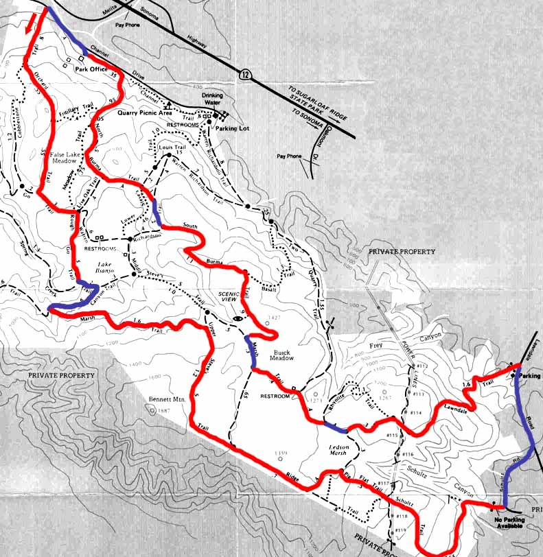
Red denotes singletrack, blue fire roadDirections from SF:
Trail Map: Click Here(Keith Flood)
Photos: Trail photos(bmxnonstop.com)
More info: Ride info from Keith Flood
Boggs Mountain (max singletrack loop)
Type: Singletrack, not very technical
Distance: ~13-mile loop
Location: Cobb, CA [Map it]The Boggs Demonstration Forest quickly demonstrates why Bay Area bikers regularly make the trek - great singletrack. Would be a definite Bay Area Top 10 except for one thing - it's not quite in the Bay Area. We're talking Lake County, a 2 1/2 hr drive from SF. So, is it worth it? While stuck in traffic near Santa Rosa, the answer is no. After a few stretches of Boggs' prime singletrack, the answer quickly shifts to yes. Most of the terrain is not that steep or technical (with the exception of a few spots on John's Trail), allowing you to fly through the forest in a curvy, tree-blurring frenzy. The epitome of this is the Hobergs Loop Trail (run it CCW) - a muted, pine-needle layered bomb with a quick detour at the bottom that lets you try it again. Views are minimal in Boggs, but an added plus to this ride is the amazing Gatorade at the Cobb gas station.
Recommended loop (~13 mi):
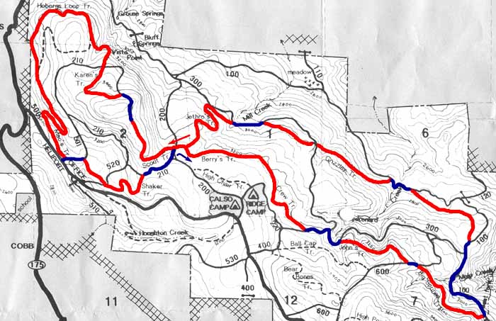
Red denotes singletrack, blue fire roadDirections from SF (~2 1/2 hrs):
Trail Map: Click Here(apgar.net)
Photos: Assorted trail shots(bikecal.com)
More info: Ride info from Keith Flood
Camp Tamarancho
Type: Singletrack
Distance: 8.5-mile loop
Location: Iron Springs Road, Fairfax, CA [Map it]Built specifically for mountain bikers, this rugged loop approximates the perfect ride. Nine miles of continuous singletrack passing through all variety of vegetation - chapparal fields, towering redwood groves, "one match" meadows, rock gardens, and creek crossings - connected with long switch-backing ascents and descents. Counter-clockwise may be the better route (debatable) as this sends you down the Serpentine Trail - a long, steep series of tight switchbacks. (I put my foot down once in this section - see if you can beat that.) This place even has great views. Not sure if anything in the Bay Area can beat this - plan on going back soon. Can be combined with the Pine Mountain Loop for an epic-status ride.
Directions from SF: (~40 min)
Trail Map: Click Here(boyscouts-marin.org)
Photos: Camp Tamarancho - Wagon Wheel Trail(marintrails.com)
More info: Friends of Tamarancho (purchase required trail-use permit here)
China Camp (max singletrack loop)
Type: Singletrack
Distance: 10.3-mile loop
Location: N. San Pedro Rd., San Rafael, CA [Map it]Bay View Trail to Oak Ridge Trail to Shoreline Trail. Sweet, moderate singletrack with impressive bay views. A fling around the loop will take about 1 1/4 hrs, ideal for a mid-week after-work ride. Remember to stick to the singletrack and avoid veering up or down fire roads. Especially avoid the Ridge Trail going south - it becomes too sandy to bike, almost like volcanic ash. I made that mistake once and am still dusting off my shoes.
Recommended loop (10.3 mi):
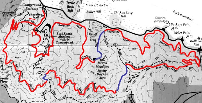
Red denotes singletrack, blue fire roadDirections from SF: (~35 min)
Trail Map: Click Here(marintrails.com)
Photos: The cool forested bliss of China Camp(gorp.com)
More info: Detailed route summary(marintrails.com), also: Info on the "fabled backside" singletrack of China Camp(mtbreview.com)
Eldridge Grade/East Peak Mt. Tam Loop (from Phoenix Lake)
Type: Fireroads, rocky in sections, paved section along ridgeline
Distance: 15.7-mile loop
Location: Near Ross, CA [Map it]This ride puts the mountain back in Bay Area mountain biking. Basically an up-and-down, the loop consists of a gentle, continuous fireroad climb of ~2300 ft to the saddle between the East and Middle Peaks of Mt. Tam followed by a ridgeline traverse and descent to the start. The climb gets progressively more technical and ends in a rock-strewn last push to the ridge. Bikes are not allowed at the summit of East Peak, so if you want to go up to the top bring a bike lock. The views from the top are worth it (see below), but the sucky firetower/cabin thing is kind of a buzzkill. Be prepared for bees along the ridge - a yellowjacket ate my friend for lunch. The long and rocky descent, as I have come to expect with my crapola bike, popped my back tire. In the process of changing the tube, I lost the plastic acorn hub that keeps the wheel on its axis. After twenty minutes of sifting through leaves (with the assistance of another passing biker), I finally found the acorn (FYI next to a real acorn) and bombed down the never-ending fireroads to Phoenix Lake. All and all, a great workout, but the lack of singletrack ranks this ride outside of the top 10. Quite possibly, one of the many illegal singletrack routes coming off the ridgeline could have made this a top 10 ride...
Directions from SF: (~35 min)
Trail Map: Click Here(marintrails.com)
Photos: 360 degree view from near the top of the East Peak of Mt. Tam (a short hike from Ridgecrest Blvd)(virtualparks.org)
More info: Detailed route summary(marintrails.com)
Lakes Loop (Mt. Tam Watershed)
Type: Fireroads, one paved section, not technical
Distance: 9-mile loop
Location: Near Ross, CA [Map it]Gentle fireroad loop that passes around four lakes under the shadow of Mt. Tam. A great late afternoon ride, a perfect answer to the 4pm “I should have gone riding today” thought. Although impossible, it really feels like there is more downhill than uphill. The last descent down the Eldridge Grade fireroad just keeps on going, with great views to the north. Keep in mind that swimming’s not allowed in any of these lakes – I saw some girls getting fined by a watershed ranger.
Recommended loop (9.1 mi):
The best way to do this loop is CCW.Directions from SF: (~35 min)
Trail Map: Click Here (note: this map shows distances CW; loop is better if done CCW)
Photos: Near Phoenix Lake
More info: Detailed route summary (note: details shown are for CW loop; better if done CCW as detailed above)
Marin Headlands Mega Loop (Tennessee Valley Rd.)
Type: Mostly fireroads, two stretches of singletrack
Distance: Approx. 16-mile loop
Location: Tennessee Valley Rd. [Map it]Accessible via a long bike ride from SF over the Golden Gate, but starting from Tennessee Valley Rd. cuts to the chase. As far as I know, this mega-loop that I've pieced together (which can be broken up into two separate loops, one with two variations) is the definitive Marin Headlands experience, containing two of the only legal singletrack sections left in the area (one uphill only). Ride up from the east edge of the parking lot at the end of Tennessee Valley Rd. to a height of land, then descend to the bottom of Miwok Trail. An aerobic switchbacking (8 or so that all look the same) fireroad ascent puts you at the top of an ocean-view vista. Slightly past this point, veer to the left onto singletrack for your high-speed reward all the way back to the parking lot.
If you still have some energy to burn, continue on the Mega Loop by veering west out of the parking lot along the Tennessee Valley Trail. Climb up the Coastal Trail (painfully steep in fits-in-starts) and begin following the ascending ridgeline. From here, you again must ask "Am I feeling lucky today?" If yes, bomb down the steep Coastal Fire Road to Muir Beach and follow it up with a great singletrack ascent (bikes allowed uphill only) back to the ridgeline. From here it's a meandering downhill down the Miwok Trail back to by now your favorite parking lot.
As always in coastal California, stay on the trail. While learning clipless, I fell sideways off the edge of the Miwok Trail into a nice fresh batch of poison oak that ate me for breakfast.
Recommended Mega-loop (approx. 16 mi):
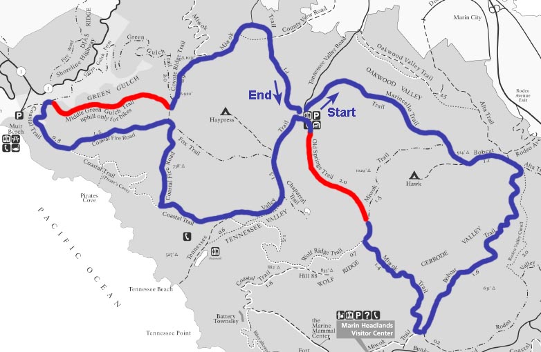
Red denotes singletrack, blue fire roadDirections from SF:
Trail Map: Click Here(nps.gov)
Photos: Idyllic conditions on the Bobcat Trail
More info: mtb.live.com
Pine Mountain Loop
Type: Rough fireroads
Distance: 13.6-mile loop
Elevation Gain: 1900 feet
Location: Near Fairfax, CA [Map it]A very scenic, strenuous, and technical loop on rocky fireroads through the Mt. Tam Watershed wilderness. There’s no singletrack, but highly recommended. The loop starts off with a couple gut-buster climbs on steep stretches of loose boulders before reaching the summit of Pine Mountain. From here it’s mild up and down through meadowy ridgelines until a progressively technical blast down to the bottom of Kent Lake. Watch out for deep wash-out trenches in the middle of the trail during this descent - I’ve done this ride twice, and both times I went astray into an eroded ditch and had to jump off my bike. A couple of minor stream crossings (no problem) and then it’s time to dig yourself out of this mess - an 1100 foot ascent lies in waiting. The loop ends with a few rocky downhill stretches that have managed to pop my tires every time so far, but this ride’s still worth the cost of a new tube.
Directions from SF:
Trail Map: Click here, Profile (from mtbca.com)
Photos: Slideshow(from bayinsider.com)
More info: Click here(from marintrails.com)
Back to Mountain Biking - Bay Area main page