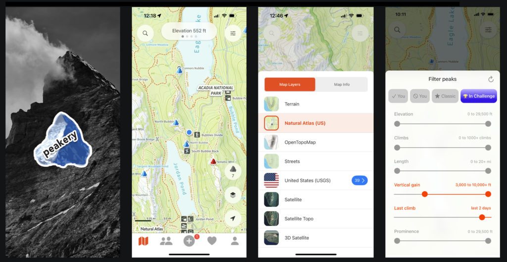
Background
peakery is a global mountain hiking guide & community. It helps you find great peaks to climb, tackle curated lists of peaks called Peak Challenges, track & collect your summits, and follow the mountain adventures of a worldwide community of passionate mountain lovers. I created the first version of peakery as a web app in 2011. In 2017, I launched a ground-up redesign of the web app that made it responsive and added a large number of features.
Reasons to build an iPhone app
However, a responsive web app didn’t allow a couple key features needed to accelerate the growth of content and usage:
1. Recording GPS tracks directly in the app
GPS tracks are a key piece of content for many reasons including:
- You can calculate all the important stats such as length, vertical gain, and elapsed time from them.
- They can be used to determine the routes climbed most frequently on each peak.
- They are invaluable to follow on a map when navigating your own climb (aka “Ghost Tracks”).
Users of the peakery web app had to laboriously import their GPX files from other sources which usually involved the extra step of transferring them from their phones/watches to their desktop. Based on our internal metrics, we were seeing that users added a GPX file to their trip reports only 12% of the time. The goal with building a native iPhone app (and also native Android app) was to greatly boost this stat.
2. Offline use when hiking
A web app didn’t allow for the future inclusion of completely offline access, a key feature for hiking in remote mountain areas with limited or no mobile service. First, we made sure that tracking new climbs will work when completely offline. Next, we’re currently working on making content & maps accessible while offline.
Design solutions
A rich GPS tracking experience
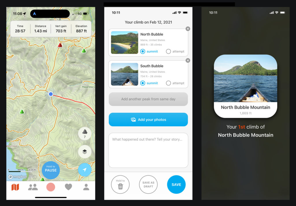
To boost the GPS tracks of peakery, we made recording a new climb the central action of the app and created a rich & compelling tracking experience:
- Single screen tracking experience: while hiking, the map and live stats such as your time, distance, current elevation, and vertical gain are all shown together in the same view, optimal while on the move.
- Full app access: designed the tracking mode to allow you to access any other part of the app while tracking in case you want to reference something such as a useful trip report.
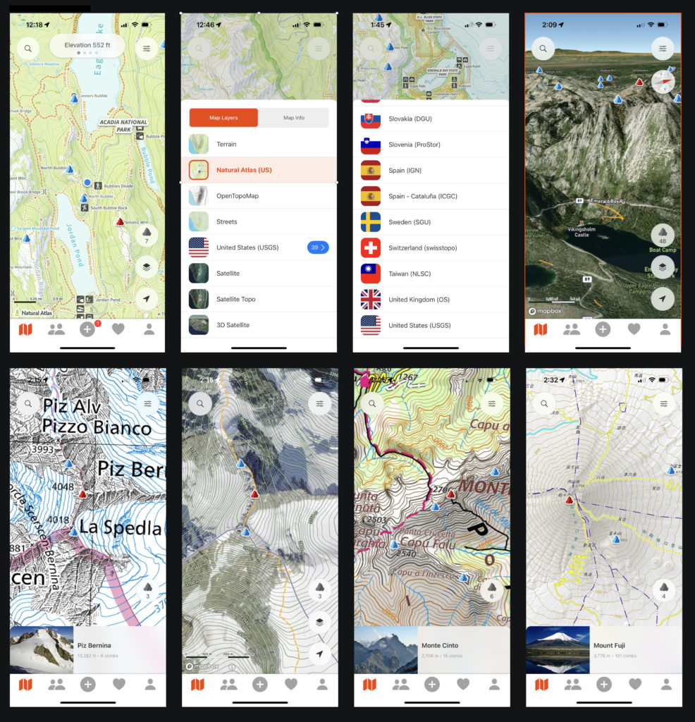
- Quick access to huge selection of base maps: easy selection of any of 46 different map layers including official topo maps from 39 countries and detailed 3D maps.
- Allow Ghost Tracks for navigation: you can easily choose to show any peakery track on the map to use as a reference when hiking. Additionally you can import tracks from external sources to use as Ghost Tracks.
- Hold to Pause/Finish buttons: in testing we noticed sometimes we’d stop the tracking by accident. By changing the buttons to require holding for a couple seconds, we solved this issue.
- Auto-matching of peaks: upon finishing your track, peakery will automatically find any known peaks in your track and populate them on the form. Provides a moment of delight.
- Background photo upload: Lets you skip the wait as your photos are uploading.
- Fully backed up on device: don’t lose tracks when your phone runs out of battery or when you try to finish your hike while offline. The app stores a complete backup on your phone until successful submission to the server.
- Multiple track support: Record multiple tracks over many days when offline for extended periods. When you get back online you can upload them all.
- Save as draft: Use this option when you finish a hike and you’re not ready to upload your trip report/photos right then.
- Awards & badges: upon submitting your climb, you receive peak badges, Peak challenge progress updates, and other awards for notable achievements.
Due to a rollout of this approach, so far in 2023, users are adding GPX tracks to their trip reports 46% of the time, almost 400% higher than before.
The Map
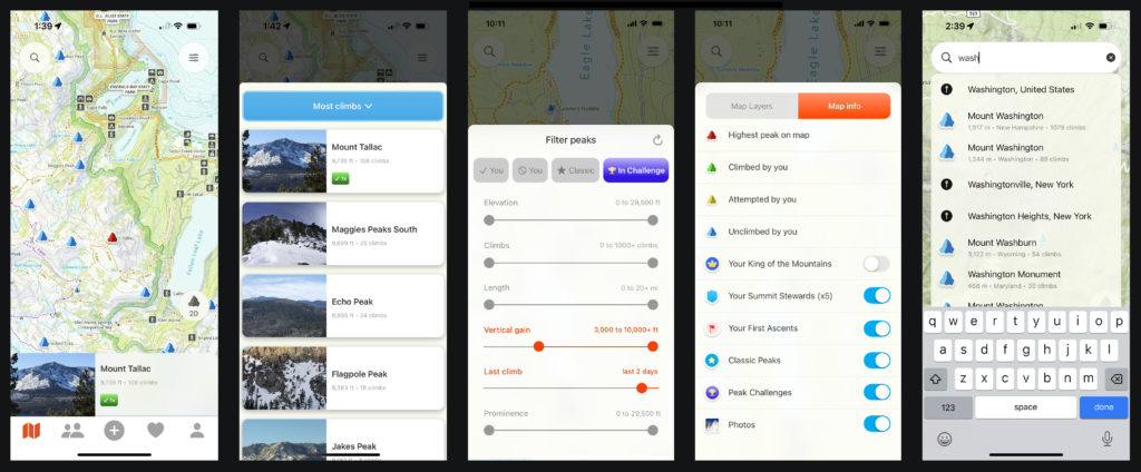
Based on web analytics, surveys, and direct feedback from users, one thing stands out: the peakery map is beloved. Many users cite peakery’s broad & deep coverage of 600K peaks as indispensable when looking for new peaks to hike nearby. The iPhone app makes the Map as the default tab and improves on-map discovery with new features such as filters for distance, vertical gain, popularity, last climbed, whether you’ve climbed a peak or not, a new concept of featured peaks called Classics, and an easier way to find Peak Challenges to pursue right on the map. A conscious design decision was maximizing the size of the map and simplifying UI elements to the minimum required, something lacking in many other outdoor recreation apps. Additionally, this design seamlessly integrates over 40 high quality base maps and makes switching between them easy.
Community
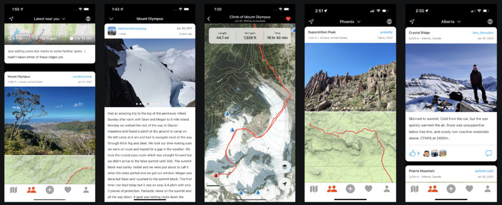
This app design also gives weight to the social side of hiking in the mountains. In the prominent feed, users can interact with the latest adventures of other passionate mountain enthusiasts in any one of thousands of regions around the world. Browse photos, save tracks for reference, give a like or comment. The feed has a default view showing all of the recent trips “near you”, a quick way to get a real sense of the latest activity and hiking conditions nearby. As well, you can quickly change to see the latest climbs near any city, state, country, and the overall world. Icons are shown for the world and nearby views for quick access.
Routes
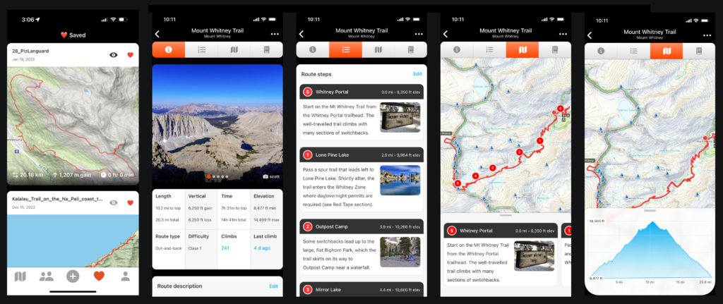
Another goal of this app design is to give people all of the info they need to go out and hike a mountain. While GPX tracks and photos are a key part of this, more detailed route info is sometimes desirable, such as directions to the start, parking, road status, red tape, weather, hazards, and step-by-step written route descriptions. This design accommodates all of this additional info. As well, a Saved tab lets you collect tracks you’d like to reference in the future. You can toggle each track’s visibility on and off on the Map.
Check out the latest!
Most of this design is live in the App Store right now and we’re actively working on adding the remaining features. Check it out here:

